At its height, Rome was a city of more than one million people. With so many people to supply entertainment, housing, bathing, food, religious spaces and fresh water to, the city of Rome had a plethora of sporting venues, temples, bath houses and aqueducts. Let’s take a look at ancient Rome on a map and explore the many fascinating buildings and monuments that made up the heart of this ancient civilization.
Map of Rome
This map was made by S.B Platner and was produced in 1911 for his book “The Topography and Monuments of Ancient Rome”.
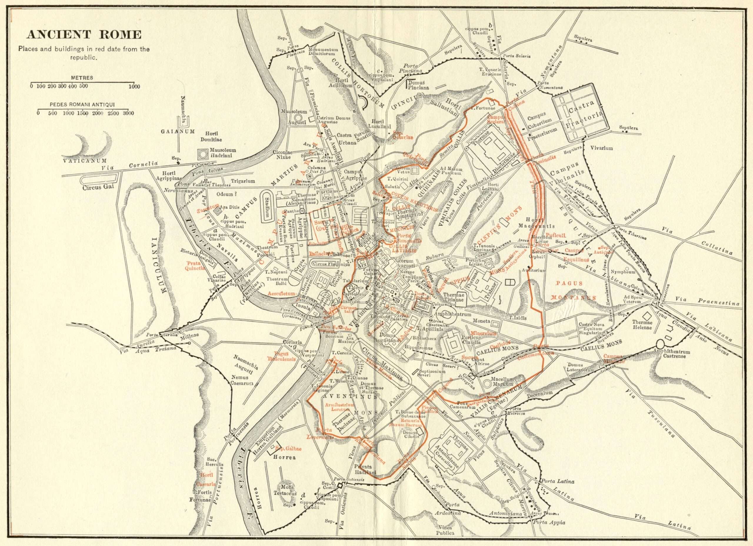
Public Domain
As you can see, it is quite a detailed map and it looks quite busy – well, that’s because it was. With over one million inhabitants (mainly of the slave and plebeian class), the leaders of the republic and the empire needed to provide food, shelter, water and entertainment to the masses.
The first thing to notice here is the red markings on the map. As denoted on the map itself, markings in red are places and buildings constructed during the era of the republic. Much of the rest dates from the imperial period.
You will also see that the names are written in Latin. Back in 1911, it was still common to write scholarly pieces in Latin, particularly law and medical texts.
In this instance, as we are talking about ancient Rome when everyone spoke Latin, it makes sense to use Latin names. It also helps others who are using this as a scholarly resource to match these names up with other sources that use Latin text as well. Matching inscriptions on the actual buildings with what is written on the map helps get a sense where one is when visiting the ancient city.
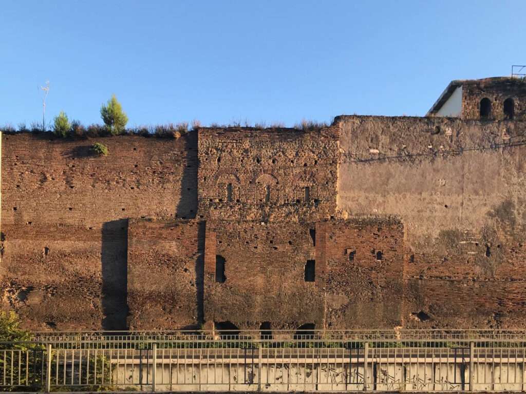
Servian Wall
The red outline that encircles most of the central part of Rome is the Servian Wall. It is said to be the first wall around the city. It was named after Servius Tullius, who ruled during the regal period before the Roman Republic. However, it appears that most of, if not all, of the wall was built during the republican period during the early part of the fourth century BC.
It ran for a length of approximately 7 miles (11 kilometers), reached a height of 33ft (10m) in some areas and was about 12ft (3.6m) thick.
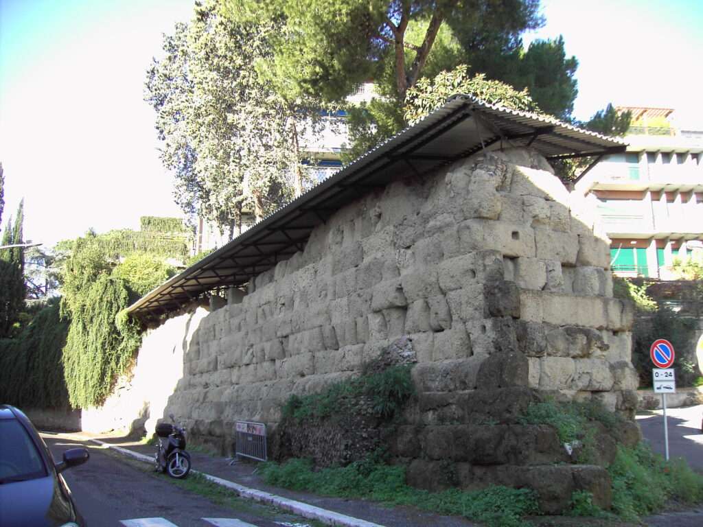
By Lalupa – Own work, CC BY-SA 3.0
As Rome grew over the centuries, it outgrew the old boundaries of the Servian Wall. However, it was not until almost 700 years later that the city would get new defensive fortifications surrounding the city.
It must be remembered that during this time, Rome was THE superpower in Europe. Its borders were over a thousand miles away and they had such a command of the Mediterranean, that it was commonly referred to as a ‘Roman lake’.
Aurelian Wall
It was not until the reign of Emperor Aurelian that Rome received significant defensive upgrades. The wall was constructed between AD 271-275. This is marked by the bold black outline on the map.
The new walls were needed because the empire was being invaded by waves of barbarians (a few barbarian tribes invaded northern Italy in AD 270, defeating the Romans in battle before being driven back), while civil wars also added to the necessity of the building project. No longer could the city rely on the absolute safety of the empire’s borders, while the army was a shadow of its former self.
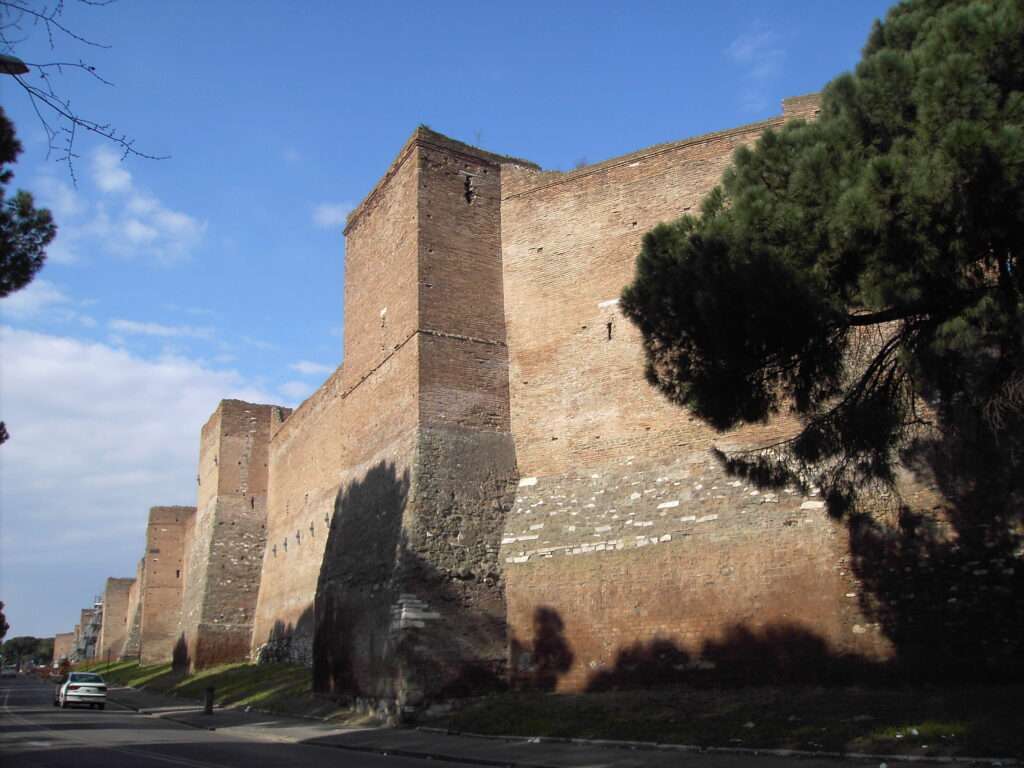
By user:Lalupa – Own work, Public Domain
The Aurelian Walls measured approximately 12 miles (19 kilometers) long, 26ft (8m) high and 11ft (3.5m) thick. The walls were improved over the next century, where the height was doubled to 52ft (16m).
The walls had some major advantages over the Servian Walls, on top of being longer (and eventually a lot higher).
They were made of bricks and concrete. These materials were far superior to that of the Servian Walls, which used tuff (rocks made from volcanic material). It was also fitted with guard towers every 97ft (30m or 100 Roman feet).
Tiber River
On the left side of the map, snaking its way from top to bottom is the famous Tiber River, the lifeblood of early Rome – before the need for aqueducts arose.
Milvian Bridge
Slightly further north (not included in the map), as the Tiber bends eastward, you will find the Pons Milvius (better known as the Milvian Bridge), which is the site of the battle between Emperor Maxentius and Emperor Constantine. Maxentius crossed the bridge from the city-side over to meet Constantine’s army. A strategic error from Maxentius meant that he and his army were pinned between Constantine’s army and the Tiber River.
When things started to turn bad for Maxentius, his army tried to retreat over the bridge. The calamity that ensued resulted in many soldiers losing their lives from drowning in the river, including Maxentius.
Tiber Island, Fabrician & Cestian Bridges
The second bend in the Tiber River from the bottom of the map, you will see a small island, labelled ‘Insula’. That is Tiber Island. That was the site of many Roman temples and is currently home to a hospital that has been operating there since the 16th century.
By Jean-Pierre Dalbéra CC BY 2.0
The island is connected to the west by the Pons Cestius and to the east by the Pons Fabricius (Fabrician Bridge). The Pons Fabricius is Rome’s oldest bridge, having been constructed in 62 BC. It replaced an earlier wooden bridge in the same spot that had been there since Rome’s earliest days, meaning it remains Rome’s only original bridge still standing.
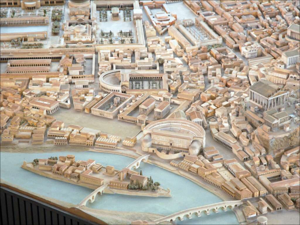
Field of Mars & Theater of Marcellus
The Pons Fabricius connects to the mainland at the Campus Martius (Field of Mars) at the doorstep of the Theatrum Marcelli (the Theater of Marcellus).
It must be noted that all the land to the west and northwest of the Servian Wall (red outline) up to the Tiber was once considered the Campus Martius, which is where soldiers used to muster before heading out of the city. Due to the expansion of the city, the Campus Martius got smaller and smaller over time.
Circus Maximus
Slightly to the southeast of Tiber Island you will find the Circus Maximus, which is renowned for its chariot races. It was used for gladiatorial battles, beast hunts and other spectacles before the construction of the Colosseum.
Palatine Hill, Domus Augustana & Tiberiana
Just north of the Circus Maximus is the Palatine Hill (the Circus is located directly in between the Palatine Hill and the Aventine Hill), where we find the Domus Augustana (part of the Palace of Domitian – not related to Augustus) and the Domus Tiberiana (possibly built by Tiberius).
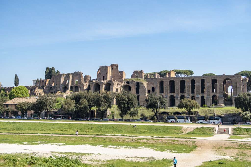
By Lil Herodotus – Own work, CC BY-SA 4.0
Temple of Castor and Pollux, Temple of Vesta
Slightly north of that and off the Palatine Hill, there is a spot marked T. Castor. That is the Temple of Castor and Pollux. To the right of that, there is the spot marked Vestae, which is the Temple of Vesta.
Colosseum
Heading east, we find the Colosseum, which is labelled Amphitheatrum. This is because in antiquity, this is what the Colosseum was known as. The name, Flavian Amphitheater, was a modern name given to it as it was built during the Flavian dynasty.
There is also little evidence to suggest that Romans called it the Colosseum either, with the term likely originating in the middle-ages. It was also spelled Coloseum and Coliseum in medieval times.
The name is also likely derived from the fact that there was a colossal bronze statue 98ft (30m) tall of the emperor Nero (that was later changed to the sun god, Sol) that was placed next to it (it was originally on the Palatine Hill and was part of Nero’s Domus Aurea or Golden House).
Colossus, Arch of Constantine
The Colossus is depicted on the map, next to the Colosseum. You can also find the Arch of Constantine (Arcus Constantini) nearby.
Temple of Peace, Forum of Augustus, Forum of Caesar and Forum of Trajan
Slightly to the northwest, past the Templum Pacis (Temple of Peace) you will find the Forum Augusti (Forum of Augustus) and Forum Caesaris (Forum of Caesar). Just beyond that, you will find the Forum Traiani (Forum of Trajan), which houses libraries, the Basilica Ulpia, Temple of Trajan, Trajan’s market and Trajan’s Column.
Baths of Diocletian
Travelling northeast, you will find the Thermae Diocletianae (the Baths of Diocletian). Construction for the baths were started in AD 298 under Diocletian’s co-emperor, Maximian and completed by Constantius. They were in use until AD 537, when the Ostrogoths cut the water supply by destroying parts of the aqueducts during the Siege of Rome.
Castra Praetoria and Campus Cohortium Praetorium
You will also see the Castra Praetoria (the barracks of the Praetorians) incorporated into the Aurelian Wall. This is where the emperor’s elite bodyguard, the Praetorian Guard camped, slept and trained (they would have trained in the grounds of the Campus Cohortium Praetoriarum.
By Gustavo La Pizza – Own work, CC BY-SA 4.0
Castra Urbana and Arch of Hadrian
This is where the Cohortes Urbanae (Urban Cohorts) were also stationed. They were considered the police and ‘riot squad’ in Rome. They were there until AD 270, when emperor Aurelian moved them to the Castra Urbana (located west and near the crease in the map picture). Right next to it is the Arcus Hadriani (the Arch of Hadrian)
Baths of Nero and Alexander
If you travel southwest from the Castra Urbana, you will come across the Thermae Neronianae (Alexandrinae – The baths of Nero and Alexander). This complex was built by emperor Nero in the early AD 60s and was rebuilt be emperor Alexender Severus in the late AD 220s.
Stadium of Domitian
The Stadium of Domitian (marked as ‘Stadium’) is located next to the baths and was built by emperor Domitian in AD 86 and was the main arena for athletic events in Rome.
Theater of Pompey
South of the Stadium of Domitian is the Theatrum Pompeii (Theater of Pompey). This theater, with the associated Porticus Pompeiana, was built and paid for by Roman general and aristocrat, Gnaeus Pompeius Magnus (Pompey the Great) and was completed in 55 BC.
Portico of Pompey, Baths of Agrippa, Crypta Balbi and Theater of Balbus
Just to the right of the Porticus Pompeiana (Portico of Pompey), there is an unmarked area that is bordered by the Thermae Agrippae (Baths of Agrippa) to the north, the Porticus Pompeiana to the west, the Crypta Balbi (which was a portico attached the Theater of Babli – built by Lucius Cornelius Balbus) and an unnamed road to the east.
Largo di Torre Argentina
This area is where you will find the Largo di Torre Argentina (Argentina Tower Square). Here you will find four ancient temples (which had not been discovered when this map was drawn) and the Curia Pompeia (Curia of Pompey). It is here that Julius Caesar was assassinated on the Ides of March (15th March) 44 BC.
Pantheon
Backing onto the Thermae Agrippae and opposite the Baths of Nero is the Pantheon. The Pantheon that currently stands is the third iteration of the building, with the first Pantheon being completed by Marcus Vipsanius Agrippa during the reign of emperor Augustus (27 BC – AD 14). This is where we get the famous inscription that adorns the Pantheon from. The inscription reads:
M·AGRIPPA·L·F·COS·TERTIVM·FECIT
This means “M[arcus] Agrippa L[ucii] f[ilius] co[n]s[ul] tertium fecit”, which in turn roughly translates to “Marcus Agrippa, son of Lucius, consul in the third term, built this”.
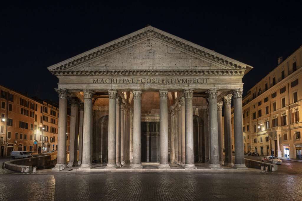
By Jfabrix101 – Own work, CC BY-SA 4.0
The first iteration of the Pantheon was destroyed by fire in AD 80. It was rebuilt by emperor Domitian but was again destroyed by fire in AD 110. This last iteration was completed during the reign of emperor Hadrian (AD 117 – AD 138).
Aelian Bridge
Heading northwest from the Pantheon, we come to the Tiber and cross the Pons Aelius (Aelian Bridge).
Mausoleum of Hadrian
Crossing the bridge, we come to the Mausoleum Hadriani (Mausoleum of Hadrian), which is known today as the Castel Sant’Angelo. This building was originally constructed to hold the remains of Hadrian and his family after they died. It was finished a year after Hadrian died, however his remains eventually made their way there. It was used for this purpose for future emperors, with Caracalla being the last emperor interred there in AD 217.
Mausoleum of Augustus
If we head east, back over the Tiber, we come to the Mausoleum Augusti (Mausoleum of Augustus). Built by emperor Augustus in 28 BC, it measured 295 ft (90m) in diameter and 137ft (42m) in height.
As with the Mausoleum of Hadrian, the Mausoleum of Augustus was constructed to house the remains of Augustus and his family, while other Roman figures were eventually interred there.
Among those interred include Augustus, Marcus Claudius Marcellus (the first person interred there), Tiberius, Claudius and Nerva.
Seven Hills of Rome
Just a few more noteworthy things. The seven hills of Rome are:
- Aventine Hill (Aventius Mons) – Located directly southwest of the Circus Maximus
- Palatine Hill (Palatium) – as mentioned before, it is located right next to the Circus Maximus to the north.
- Capitoline Hill (Capitolium) – this is directly opposite to the Palatine Hill to the northwest, with the Servian Wall constructed on its western side.
- Quirinal Hill (Quirinalis Collis) – Located northeast of the Capitoline Hill
- Viminal Hill (Viminalis Collis) – Located next the Quirinal Hill
- Esquiline Hill (Esquiliae) – Marked as Esquiliae on the map but should read Esquilinus or Collis Esquilinus. Located east of the Viminal Hill.
- Caelian Hill (Caelius Mons) – Located south of the Esquiline Hill
Other Places
Whenever you notice the word ‘Porta’ along the Servian or Aurelian Walls, like Porta Appia, Porta Flaminia etc., that denotes one of the gates into the city.
Whenever you see ‘T.’ followed by a name, that is a temple – T. Castor is the Temple of Castor.
Whenever you see ‘Aqua’, that is an aqueduct – Aqua Traiana located on the far west of the map is an example.
In that same area, you will see ‘Via’ (Via Aurelia). That is a road.
Horti means gardens. North of the Via Aurelia, you will see Horti Agrippinae (‘Gardens of Agrippina’). While in the northeast of the map, you will see Collis Hortorum, which is basically ‘Hill of Gardens’.
The Via Appia (Appian Way) runs south-west from the Colosseum then continues south, through the Porta Capena and then through the Porta Appia at the bottom of the map. It is considered ancient Rome’s first ‘highway’. It eventually led to the southeastern town of Brundisium. Brundisium is where the Roman army would set sail from if they wanted to travel east to Greece and Asia Minor or southeast to Egypt.
There’s plenty of other buildings and monuments in the city of Rome. One could spend hours looking up all the places on this map and learning more about the Eternal City. There is also plenty still to uncover.